How can you measure the height of a shooting range's berm / backstop?

Status
Not open for further replies.

CoRoMo

Member
Joined
Sep 21, 2007
Messages
8,952
Location
California Colorado
This drawing is a relative representation of the shooting range on my land. I shoot into a dam that I can only guess is 15' - 30' high, and for that guess, I'm using the vertical identified as 'B' in the drawing. As you can see, the bench is a few feet in elevation above the low spot where the 'B' measurement would be taken.

The distance from the bench to the dam is roughly 145 yards.

When talking to neighbors, I'd like to be able to accurately describe the height of the dam that I shoot into.

But I have no idea how to make any of these measurements. How would you suggest getting a measurement, of both A and B? Without costly survey equipment, that is.

index.php
 

Attachments

  • backstop.png
    backstop.png
    331.5 KB · Views: 374
Half a foot or less?

The only thing I'd come up with was a water column level, but that would require many dozens of yards of tubing; maybe 60+ yards or so just for the 'B' vertical. There would be no way I could get a hold of 200 yards of tubing for the 'A' measurement.

Also, I'd have to have something like a ladder that I could climb up to the height, out there in the range, to get the water column to level. This isn't feasible after all, unless anyone here can figure out an easier way at it.

And then we came up with the Pythagorean theorem, by stretching a wire from the top of the dam, down to the base of the B vertical. You could measure that length easily, but you'd need a second leg of the triangle in order to figure out the rest.

Talking this over with one of my engineer siblings and with one of my employees, I think I might have an easier way to do this now.

Still open to all suggestions though.
 
Last edited:
Half a foot or less is going to be difficult or impossible without surveying equipment. I think your best bet is to use a handheld GPS and make the calculations that way, but you will have to accept the associated inaccuracy. If you really need it within 0.5' then I would suggest borrowing or renting a construction or surveying grade level with a tripod and level rod. Leveling is going to be the easiest way to do this without having to learn to use a total station / theodolite or survey grade GPS. (I am a professional land surveyor).
 
If you go with a handheld GPS, record multiple positions on each point at various times of the day and average them. If you are going to record more than one position on a point at the same time, I would suggest turning off the GPS in between. It breaks the lock on the satellites and forces it to calculate the position anew. It isn't perfect, but I think it is good enough for what you want to do.

The elevation accuracy of a handheld GPS is going to be pretty poor in general, but it may work just fine for relative positioning. In other words, the elevations that you obtain may not be accurate to their true values, but as long as the handheld GPS can establish their positions relative to one another within reason then it will be suitable. Taking multiple positions will help you know whether or not the unit you have is capable of accomplishing this task.
 
Last edited:
CoRoMo wrote:
And then we came up with the Pythagorean theorem, by stretching a wire from the top of the dam, down to the base of the B vertical. You could measure that length easily, but you'd need a second leg of the triangle in order to figure out the rest.

If you run a wire from the crest of the dam to the point where "B" intersects the ground, you have everything you need. Use a string with a weight on it to establish a vertical line. Measure the angle between the vertical and where the wire intersects the ground. Subtract that from 90. That will give you the angle between the horizontal and the wire which is the hypotenuse of your triangle. The rest is simply trigonometry.

How you measure the angle will determine whether you can get to within your half-foot tolerance.

You can pick up an old optical transit on eBay for less than $100, use it and then put it back on eBay and get most of your money back (less shipping).
 
Last edited:
I would rent a total station from a survey shop and shoot it with a friend holding the target rod. It you raise the target up to the top of the berm you should be able to shoot the distance and have the total station give you the distance to target the angle of inclination and the the height.
 
I would do something similar to what hdwhit suggested. Measure 50 yards or so from the berm and shoot an angle from the ground to the top of the berm with a clineonometer or protractor. Then I'd plug the numbers into an online trigonometry calculator. You could measure from the bench but I figure the closer you are the more accurate you'll be.
 
Using clinometer or a hand level (scope with a level bubble and crosshairs) are both valid ways to measure the berm, but I think you'd be lucky to get within 0.5'. A transit would be a better option, but if it were me, I'd use it as a level (i.e. locked at 90°) with a 25' Philadelphia Rod.

Using a level is really pretty simple. You setup your level and level it on a tripod, preferably roughly an equal distance between your shots, then add your backsight and subtract your foresights.

So let's say pont A is your backsight and you assume it to be 100.00 feet. You sight the rod and read 5.12 feet. The height of your instrument is 105.12 feet. Then you sight point B and you read 8.50 feet. You subtract 8.50 from 105.12 to arrive at an elevation of 96.62 feet for point B.

Sharp changes in topography like a 30 feet tall berm can make leveling a challenge, especially if you don't want to have to level up the side of the berm. If the berm is actually about 20 feet tall or less, you could setup on top as low as you can get and try to do it that way. You would be reading the top of the rod where it would be least accurate due to any divergence from plumb, but it would still work.

Or if the face of the berm is pretty sheer you could invert the rod and have the bottom of the rod at the top of the berm and use it as a negative reading. So let's say the height of your instrument is still at 105.12 and you invert the rod and get an upside down reading of 15.50 feet. This is really a reading of -15.50 feet, so you would then compute 105.12 - -15.50 or 105.12 + 15.50 feet for an elevation of 120.62 for the top of berm.
 
Last edited:
Use a tall step ladder and a long level near the bench. The height where the level, when level, points at the top of the dam is where to measure from the ground to. Cheap version of a transit.
 
If you have a fairly accurate barometer, take a pressure reading at ground level and again at the top.

The pressure drops about .01 inch (i.e. 29.92 to 29.91) for every 2 meters, at 15C temperature.
 
Last edited:
Step ladder, tape measure and a strong string with a cheap line level.

Tie string to base of tree or stake at top of dam.

Set up ladder near where you have the 'B' line intersecting the ground.

Put line level on string, climb the ladder and pull as tight as you can (then pull some more). Move line up and down until you get level.

Measure from that point to the ground. (would help if you had a partner)

You may have to move your ladder back toward the bench depending on your ladder height and the height of the dam.

You have your dam height.

You should be able to get the line, level and a tape measure for about $10.


,
 
I'm not sure why you need such a measurement, the only one that really counts is from where your targets are located to the top of the dam unless you are either putting targets way in front of the dam (ricochet problems) or have inadequate safe space behind it and need to extend the "roof" lower at the firing line to make it impossible to line up a shot over the berm (dam), in which case you should be able to line it up visually.

At our club there are many ranges and none of the berms are more than ~20' tall although they are heavily vegetated so its a bit hard to be sure, many have an additional 10-20' of brush and trees growing above the bullet "cut zone" as the club has been there for a long time. The key is keeping the targets close to the backstops to "cut down the angle" of any ricochets from horribly low shots so they can't get over, and have the backstop be tall enough that no responsibly aimed shot would go over. At our bench rest only range where there is the smallest safe zone behind it, there is an "eye brow" in front of the firing line that prevents a line of sight that could get a shot above the berms. A 25 yard "sight-in" target has a seperate ~10 ft dirt pile just behind the target board which sits to one side of the longest distance (200 yard) backstop.

If you have incompetent shooters that could fire errant shots at ~45-58 degree angle you'd need a couple of miles of safe zone in all directions -- its why public ranges are going away as civilization encroaches :(
 
I was thinking along the same lines as others using a step ladder, but I'd use one of my laser levels and point it at the top of the berm in near dark conditions. A long pole could somewhat work in place of a ladder. Maybe a ladder and pole, at your shooting bench side to elevation.

I've done this to check the foundation height of my home above street height for flooding concerns.

If you have a laser level, of course.

EDIT to add: I have the predecessor to this low end laser level by Black and Decker. It hangs on a pivot so that it seeks its own level. I use it several times a year for simple things like hanging photos on a wall or drapery rods. It comes in handy for all sorts of things, which means it's not just a one time use tool.
 
Last edited:
http://files.dnr.state.mn.us/education_safety/education/plt/activity_sheets/howToUseAClinometer.pdf

Surveyors used to use clinometers all the time for imprecise vertical measurements like this. They don't much anymore as total stations gather the information much faster in a digital format. The concept and the math is the same however, just computerized using a laser.

I used to have a clinometer and a compass in my vest because that's what we used before total stations replaced them.

If you know any trig it will be a snap. :D
http://www.forestry-suppliers.com/t01_pages/pdfs/M0003.pdf

If you were my neighbor I'd do it for you for a beer.
 
Last edited:
Find a local contractor and pay him for 1/2 hour or so time it takes to measure it. He can use his equipment to measure it and save you a bunch of time renting or buying the needed equipment. Then you would have to learn how to use it. Might even make a new shooting friend at the same time. YMMV

You might even be able to use google earth to ID the height somewhat accurately. I find my house is 43 feet below the level of the street that passes by it.
 
http://www.estesrockets.com/media/c...3525d08d6e5fb8d27136e95/0/0/002246_main_2.png . OR
3) Optical Tracking
So far, small rockets have proven troublesome in our desire to measure altitude. They’re too small for an electronic system and they’re too small to carry a streamer payload. To track something like the Quark, we'll need to use optical tracking. There are several methods of optical tracking and I'll discuss the simplest one here. Be forewarned, however. There's going to be some math up ahead. Remember when you were a kid and you wanted to know when you were ever going to use trigonometry? Well buddy, here it is.

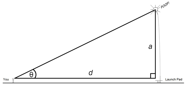
The quickest and easiest way to determine your rocket's altitude with optical tracking is to use elevation-angle-only tracking. This is a very simple method and the amount of trigonometry isn't nearly as bad as I made it out to be. Let's begin with a diagram of the launch site. If we assume that the rocket travels reasonably straight up from the launchpad, then we can draw ourselves a nice right triangle.

rocketaltitude04.png


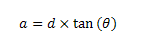
If we know the distance from our observation point to the launch pad (d) and the angle at which we can see the top of the rocket's trajectory (θ), we can calculate the altitude with the following equation:

rocketaltitude07.png


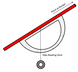
If you’re using a calculator, make sure you’re in degree mode and not radian mode. Of course, this is assuming you measured the angle in degrees, although I don’t think I’ve ever met anyone who measured rocketry angles in radians. Measuring the angle can be done with an inclinometer. The Quest Skyscope and the Estes Altitrak are two types of inclinometers specifically designed for model rocketry. If you're in a pinch, you can make your own inclinometer with a protractor, a piece of string, a washer, and a straw.

rocketaltitude05.png


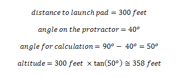
Simply track the rocket to its highest point, tilt the homemade inclinometer so that you're looking at the apogee point through the straw, and pinch the string to the protractor once the string stops moving. Subtract the number on the protractor from 90 and you have the angle you need for your calculation! Here's an example of this type of calculation in action:

rocketaltitude06.png
 
That would work as well. Once he knows what A-B= in his sketch and has something that can precisely measure the angle he could have a chance of getting accuracy pretty close.

Using something like a straw, protractor and plum bob would get you closer than guessing, if your not good at judging heights. A professional grade theodolite would be extremely accurate, once properly set up.

At 450 ft distance from the object, being off by a half degree in angle would be 48 inches difference in height, along way away from the accuracy the OP was looking for at 6 inches or less. For that you would need angular accuracy to the hundredth of a degree.

If your math lazy but still want to play, these "plug and play" calculators might be helpful.

http://www.forestryforum.com/members/donp/3treehgtclcs.htm
 
Last edited:
waterlevel-bucket-hose-300.gif


With this.

https://www.amazon.com/ATP-Value-Tube-Plastic-Tubing-Natural/dp/B00E6BB0F8/ref=sr_1_5?s=industrial&ie=UTF8&qid=1496500727&sr=1-5&refinements=p_item_length_derived:500+feet

Would be the most accurate method you could do for under $30. Actually you could probably spend hundreds of dollars, if not thousands on methods that wouldn't be as accurate.
I had considered that, but I don't think I have a way to get up to 25 feet or so to reach the water level, out in the range, away from the dam. Even using a 12' step ladder in the bed of my pickup, I still don't think it'll get me high enough, and then the falling hazards get real. Here's another picture of it just for fun.

index.php


I was thinking of simply setting one of my AR's that has a TLR-2 mounted, set it up on the top of the dam in a vice, level it dead as can be, and aim the laser out over the range. Then I'd get in the bed of my pickup with a 16' long pipe that has a sheet of card board at the top, with inch-marks drawn on it. See if I can intercept the laser in the evening with the long pipe and identify where it's hitting. It's gonna be way up there though.

It'll likely be one of these two ideas I think.

index.php
 

Attachments

  • backstop2.png
    backstop2.png
    332 KB · Views: 146
  • backstop3.png
    backstop3.png
    331.4 KB · Views: 146
Last edited:
Place a marker at the point on the ground below B.
Place a marker on the top of the dam so that the point on the ground below A, the marker at B and the marker on the top of the dam are all on a straight line.
Measure the angle upward from the point on the ground below A to the marker on top of the dam. Call it 'a'.
Measure the angle downward from the point on the ground below A to the marker at B. Call it 'd'.
Measure the angle upward from the marker at B to marker on top of the dam. Call it 'b'.
Measure the straight line distance from the point on the ground below A to the marker at B. Call it 'S'.

The height of the dam (height of the marker on top of the dam above the marker at B) is:

S x sine(d) x sine(a+d) / sine(b-a)

Measuring an angle upwards or downwards means measuring the angle that is the difference between level and the line which passes through the point being measured. You shouldn't get any negative angles or angles greater than 90 degrees.

Straight line distance is the actual distance between two points as would be measured by a laser rangefinder or a taut line/tape measure stretched between the two points.

Be aware that the accuracy of your answer will be heavily dependent on the accuracy of your angular measurements.
 
Last edited:
Status
Not open for further replies.
Back
Top