How can you measure the height of a shooting range's berm / backstop?

Status
Not open for further replies.
I had considered that, but I don't think I have a way to get up to 25 feet or so to reach the water level, out in the range, away from the dam.

My game radios work ok out to about 5 miles but they don't tolerate terrain very well. I use PVC tubing to raise the antenna 40 ft pretty easy as in compact and light weight. A large enough diameter to slip over a T post.

Maybe you just tell who you are talking to about the height it is "fill in the blank" feet tall. Then when they come back and tell you that you are wrong by 26.8 inches, you ask how they came to that number.

More of an innocent until proven guilty way of looking at it.
 
Ok, put a stake in somewhere near the top of the dam, close as you can.
Put another stake at the foot.
Connect the two with some mason's line (low stretch). You want the line as straight as possible.
Stand an upright near the bottom stake.
Hold a 4' level against the line and mark where it's level on the vertical.
Solve for your angle a via atan (v/4') (4' length of level is your 'adjacent' marked height v is your 'opposite')
Measure from low to high stake, that gives you a hypotenuse, h. sin a = h / x Solve for x and you have dam height.

Now, I have a 24" Craftsman digital level (about $70). I'd lay a 2x on the slope, then prop the level on it to get the angle reading. I'd then grab my long tape and stick the designated pawn shop phillips screwdriver in the dumb in at the bottom of the hill, then measure up at the top. Only need math once, then, as sin(angle) = hyp/height.

That is, unless I were really motivated, as I also own a transit. But, that would take a lot of stretching out tape to measure. So, I'd probably bribe my buddy Ted with some Rahr beer to just come and bring his laser theodolite.
 
This drawing is a relative representation of the shooting range on my land. I shoot into a dam that I can only guess is 15' - 30' high, and for that guess, I'm using the vertical identified as 'B' in the drawing. As you can see, the bench is a few feet in elevation above the low spot where the 'B' measurement would be taken.

The distance from the bench to the dam is roughly 145 yards.

When talking to neighbors, I'd like to be able to accurately describe the height of the dam that I shoot into.

But I have no idea how to make any of these measurements. How would you suggest getting a measurement, of both A and B? Without costly survey equipment, that is.

index.php
Study ancient Roman surveying techniques.

From point 1 sight along a yardstick, with a bubble level attached, to a pole held vertical at point B, this will give you the vertical distance from 1 to B.

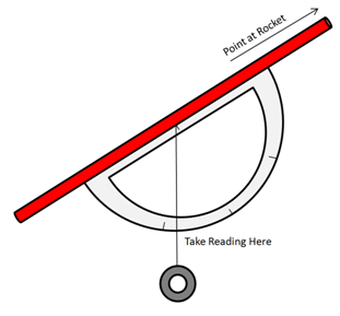
Next, take a protractor with a string and weight attached at the center and sight along the straight part of the compass (see image below), with the string dangling, from Point 1 to the top of the berm. When you get a good sight, pinch the string against the compass and take the reading.

Now, the hard part, you need to get the line-of-sight distance from 1 to the top of the berm. 200 yards of 550 cord?

Apply some trigonometry and you get the height from 1 to the top. Then just add the distance from 1 to B.

Simple. (Accuracy will be around 2% the horizontal distance from 1 to the top of the berm. about +/- 9 feet for 150 yards. If you want better than that, you'll need a more accurate inclinometer.)


Home made inclinometer:
rocketaltitude05.png
 
Last edited:
You had a dialogue with your neighbors about your shooting range, and berm dimensions?
This is a subject which never came up for discussion, here. I must imagine if they are questioning
your range's construction, they may never be satisfied, as to it's soundness, no matter what
you do.
You know the height of your berm. You should be able to guess the other dimensions
within a reasonable estimation.
 
This is how to measure height. Accurate to 6" at 100ft.
This depends on being able to measure to a point directly below the peak of the item being measured. It works very well for towers and trees--not so well for mountains/hills/dams. The dam has a slope to it so it's impossible to measure directly to the point below the peak of the dam. If it were a nice constant grade then a very good estimate could be made of where the point below the peak was, but if it's an irregular slope, it's a little trickier.

CapnMac's approach will work. I thought it would be much easier to accurately measure from point A to point B rather than from Point B to the top of the dam so my approach requires more angular measurements to get from that measurement to the height measurement but it's really the same approach when you get right down to the final analysis. I'm also calculating the height from the hypotenuse and the angle from the point B to the top of the dam as CapnMac describes. The difference is that since I didn't measure the hypotenuse directly, I had to calculate it from the angular measurements taken from point A and B and the straight line distance from A to B.

The figure below shows how I arrived at the solution I provided earlier in the thread.

The hypotenuse of the triangle is calculated using the law of sines.

BermHeight_small.jpg
 
Last edited:
A GPS would be close enough for me.

It's been too long since taking geometry in HS. But if a laser range finder were placed on the bench parallel to the ground you'd get an accurate measurement to the berm at bench height. Then measure the distance to the top of the berm. Most range finders also give the angle and we already know the angle from the bottom of the berm to the top is 90 degrees. If you know the length of 2 sides of a triangle and the angle of 2 of the 3 corners I know it is possible to calculate the length of the 3rd side. Actually I think you only need one angle. I just don't recall exactly how to do it and don't feel like looking it up right now.
 
This is how to measure height. Accurate to 6" at 100ft.

There are several methods mentioned there but as above, but all of them would require a bit of luck to get you within 6" of what the dam really is.

You might be talking about the one the math gave you an answer to .5 ft but that would be a lot like me giving you a tape measure that's marked in thousandths, lots of luck you get an accurate reading with your eye at that point.

The distance between the two points isn't as critical as the angle to accuracy

If it were 450 feet apart and 1 degree inclination that would give you 8 feet of height. Of you were off a single degree at 450 ft that would give you 16 feet in height.

Let's say you were off your distance measurement by 50 ft at 500ft, the same 1 degree difference in angle would be 9ft only a 1ft error in height for 50ft error in distance. A lot more forgiving than a error in angle measurement.
 
Doing it the way you are attempting I would------
! Set your rifle level on the shooting bench and mark on the berm where the laser indicates using a point that is lined up with a marker on the berm top.
2 Set your rifle level at the top of the berm at point previously used as a marker and point it back to the shooting position.
3 Get a couple or three lengths of 1/2" electrical conduit, Enough to match height of measured area. They will slide together end to end and each one is 10 foot long. At the top in the approximate length you want, tape some copier paper or the like to the conduit and mark the height of the last section like a tape measure. Stand at the location marked at step one. Rest the conduit on the ground and wave it back and forth while vertical in line with the laser so that you can read the height. :D

ETA: the problem with the calculation method is that it is all but impossible to get distances to the right angle inside the berm without a lot of complex math to establish true lengths of the sides..
 
Last edited:
I see we are still discussing this. o_O

Here is a very cheap ($45) and easy way to do this. I should know because I spent 40 years mapping for road construction. I'm a licensed surveyor.

Buy one of these and follow the instructions to find incline angle.
https://www.amazon.com/Professional-Multifunction-Military-Inclinometer-Waterproof/dp/B00M1PWM0I

Buy a 100' tape.
https://www.amazon.com/s/ref=nb_sb_ss_c_1_17?url=search-alias=aps&field-keywords=100+ft+tape+measure&sprefix=100'+tape+measure,aps,220&crid=2HRI4DHJCF98V

Stand on top of the berm with the clino and tape. Have someone stand on the bottom of the berm with the end of the tape. Using the clino measure the angle to the person's eyes (eye to eye assuming about the same height). Measure the slope or incline distance to the person eye to eye.

Find the sine of that angle and multiply that by the slope distance. That gives you the vertical height of the berm.
Example. 20° angle, 40' distance. Sine of 20° is 0.342 x 40' = 13.7' vertical distance.

If you want to know the vertical difference from the ground at the bench to the bottom of the berm use the same procedure.
Example. -10° angle, 100' distance. Sine of 10° is .174 x 100' = -17.4' vertical distance.

If you want to know where the top of the berm is in relation to the ground at the bench, the ground at the bottom of the berm is 17.4' below the ground at the bench and the berm is 13.7' high. -17.4+13.7 = -3.7'. That makes the top of the berm 3.7' below the ground at the bench.

If you need to measure more than 100' just measure the distance 4 or 5 times using the 100' tape. If the slope is gradual the distance will be good enough for a rough calculation. Or better, borrow or buy a laser range finder.

You owe me a beer. I can do the calculation for you if you want. Just pm me with the info in that format. That will be two beers.
 
Last edited:
If you have a good accurate pressure gauge you stick it on a hose. Leave the gauge at point B and drag the other end of the hose to the top of the dam. Assuming the hose is full of water, multiply your pressure reading by 2.3 to get feet.
 
If you have a good accurate pressure gauge...

That's kind of like all of the protractor, angle finder answers what resolution do you have to get to in order to measure 6 inches accurately?

Not unlike the angle issue where you need to know the angle down to the hundredth of a degree. To measure water pressure you need a gauge accurate to the tenth of a PSI to get meaningful information.

Again if your not a math type the calculator here will save you some time.

http://www.lmnoeng.com/Statics/pressure.php
 
You need to know the distance and the angle.

For the distance you can simply range it and/or use a measuring wheel.
For the angle you will need a rod and level (construction one is fine) or if you don't have one you could do with a decent angle indicator.
Pickup as many points as you can to average / correct.

The rest is easy, it is simple trigonometry.

If you use the distance to the base use the tangent function.
Tan(your angle) = height of your dam / distance to the base.
So..
height = tan(your angle) * distance to the base.
Lets say your angle is 2 degrees and the distance 145 yards.
height = tan(3.3) * 145 = 0.576 * 145 = 8.36 yards = 25.08ft.

If you use the distance to the top with the same angle use the sine function.
Sin(your angle) = height your dam / distance to the top.
Height = Sin(angle) * distance to the top

If you don't have a wheel use a masons 25' tape or rely on the several measurements with a range finder.
Can also use a stadia like a mil dot in a scope using a calibrated board but you need to know the precise measures of the
subs-tensions and still might not be as accurate. The tape or wheel will be the best and might use another to corroborate the results.
For angle indicators you could use a masons slope level but in a pinch you could use a regular carpentry level and angle if you
can aim with it fairly accurately. The ideal would be to have a rod and level system.

This is a great way to calculate this type of things and do with several measures so you can confirm and corroborate each other.
This also works whether you are calculating 100 yards or 1000 or x miles as soon as you can identify the measuring points.

It is simple trigonometry same way survey, road engineers and masonry workers might use.
 
Hope you don't hunt. If you can't measure the berm height within 5%+ or - , you could use a range finder aimed at the top of the berm, and mathematics. Some feller named Pythagoras figured that out a few years back.
 
Hope you don't hunt. If you can't measure the berm height within 5%+ or - , you could use a range finder aimed at the top of the berm, and mathematics. Some feller named Pythagoras figured that out a few years back.
Please explain how to find the height of the berm above the low point in the OP's drawing using only a rangefinder aimed at the top of the berm and the Pythagorean theorem.
 
I am going to assume the reason why he needs to do this (and if he said so, sorry I missed it) is to prove that he is shooting in a save manner....and I get that, after a 9mm hit the night stand in my neighbors house. (this really ticks me off)

City folk come out to the "country" to act like idiots, and not think....oh you mean it can go that far....yea, you idiot.

If it is legal in your area I can tell you what we look for....is it breaking any laws.....past that the problem is all you if something goes wrong.

For me personally I shoot at home into a big U and if you want to be as close to 100% safe as you can get...point your gun at your target....can you see sky....if the answer is yes then there is a chance (read chance) the bullet can leave your range. How large is that chance....well it depends on you.

Only thing I would say if shooting into a dam....make sure you are watching for issues with the dam....don't chew too much of it away.
 
I am going to assume the reason why he needs to do this (and if he said so, sorry I missed it) is to prove that he is shooting in a save manner.

Knowing the height of a berm to the 1/2 foot or even fraction of an inch won't help that.

I have seen bullet holes in the ceiling at indoor ranges outdoor ranges that require shooters on the line to shoot through tubes at targets down range to help reduce the possibility of them shooting over the berms.

DSCN1302%20resized.JPG


In any case you don't need a 21.5 ft berm for that. My backyard bullet trap is only 16x8 and that's plenty big enough, used in a safe manner.
 
Last edited:
Um... You own a scope, right?

Even with a Plex reticle, you can judge object size if you know the distance.

If you want to go from the belly to the peak, set a colored marker at both locations so you can pick them up in the scope. With a mil-dot or other graduated reticle, glass it from the firing line, measure the mils between the two markers, shoot the berm with a laser range finder at the top, and figure the height using the same formula used to range known size objects. There's a little more math which could be done to make this more accurate, but it'll be close enough to be within appropriate tolerance.

A guy could use a cosine or angle indicator on their rifle too. Aim at the belly, mark the down cosine, aim at the peak, mark and record the differences.

The paper triangle method only works well if you're able to remain perpendicular to the vertical height.

Also note - your expectation of +/- 6" seems pretty ambitious - remember, you're measuring a natural landform. Unless you've been out there with a transit, measuring and leveling the grade and the berm, it'll vary considerably more than +/- 6", and the deepest belly going side to side of the field may not coincide with the same line of fire going side to side of the berm. For a natural landform, you might be lucky to find less than +/- 5ft of variation from left to right, comparing the height of the berm to the depth of the field. Even flat land isn't really flat over long runs, and what you have depicted certainly doesn't appear to be flat land. Given that variability for height and depth distributed across the berm and belly, measuring to within +/-6" will be exceedingly difficult, exceedingly inaccurate, and is exceedingly unnecessary.
 
Last edited:
I guess if you were worried about being able to see the water level back at the bench end you could use one of the audible water levels out there up on a section of PVC to elevate it and just plug your longer hose to it. You would need someone back there to listen for the beep.

If you fast forward to 1:10 or so you can see it would be well inside 6" as far as accuracy is concerned.


If you had a decent optic you might be better off saving the extra $30 and just drop food coloring in the water.

Or make sure the hose is above the dam end when filled and pull it down slowly until water leaks out the top and gets your hand wet. Then mark the hose at where you want the measurement to be from and that is your height.
 
Last edited:
Status
Not open for further replies.
Back
Top